|
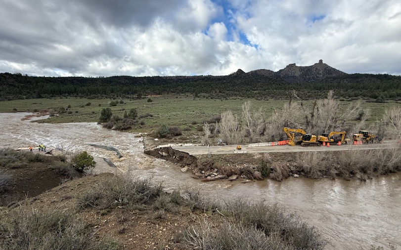
For the second weekend in a row, Southwest Colorado was hit with heavy rains and flooding that damaged roadways throughout the region. Several highways and one bridge are impassable. The impaired infrastructure adds to the list of damaged roads from the previous weekend. Colorado Department of Transportation maintenance personnel and contractors are swiftly responding with temporary repairs to open road access, where possible. Meanwhile design and engineering staff are forming plans for permanent reconstruction at some locations.
U.S. 160, considered a critical route along the southern portion of the state, has sustained damage at several separate locations along a 100-mile stretch, from Durango to South Fork.
“Our roads have sustained serious damage. While it will take time to develop plans for permanent repair and resilience, our first order of business is to get them open before winter hits,” said CDOT Executive Director Shoshana Lew. “We are grateful that the Colorado Transportation Commission and the Federal Highway Administration (FHWA) approved a combined $11.5 million — $6.5 million from FHWA and $5 million from the Transportation Commission contingency fund — that is available to us immediately to get started right now. CDOT is committed to keeping Southwest Colorado moving while we work together towards longer term recovery.”
“Communities across our region rely upon U.S. 160 to commute from home to work,” said CDOT Regional Transportation Director Julie Constan. “This highway transports goods and services in and out of the region. It’s a lifeline. We are particularly focused on getting U.S. 160 open for the community of Pagosa Springs. We understand the need to get full access in and out of Pagosa as they begin their recovery from the devastating flood.”
Following last week’s initial storm and flooding, CDOT began emergency reconstruction at several sites. The most recent storm will force additional remediation on those work sites including water removal, flow diversion and debris cleanup. Reconstruction efforts may be delayed this week due to the numerous closures limiting the transport of workers, equipment and materials to these sites.
Regional highway closures as of Monday, Nov. 2
Dozens of emergency closures have occurred over the past two weeks throughout the region. As of Monday evening of Nov. 2, multiple major closures remain in place from the previous week’s flooding, with additional extended closures implemented due to critical roadway damage that occurred during this weekend’s most recent flood event. (Note: some highway closures may have opened overnight, check COtrip for updated information.)
Colo. 151 south of Chimney Rock (MP 27 to 30) - CO 151 sustained additional roadway damage within the recently established emergency reconstruction work zone. An additional segment of roadway was washed out by flood waters on Nov. 1, about four miles south of the US 160 junction (MP 30). A construction team is already in place to continue emergency reconstruction efforts and address new damage along this highway segment.
U.S. 550 north of Durango (MP 32) - Six miles north of Durango, crews are monitoring the Hermosa Creek Bridge bridge as flood waters remain high and significant debris flows may threaten the structure, as well as the highway is inundated with water. A bridge inspection will be performed to ensure the bridge can be safely reopened to vehicle travel.
U.S. 160 Pagosa Springs to Bayfield - At least five locations along this 30-mile stretch of highway, between Pagosa Springs and Bayfield, are in need of road maintenance or emergency repairs.
- Downtown Pagosa Springs - A safety closure has been implemented through the downtown stretch of Pagosa Springs to assist with evacuation and emergency response activity. Once flood water recedes, the San Juan River bridge will undergo an inspection.
- Piedra River Bridge (MP 121) - The bridge’s piers collapsed. Located 18 miles west of Pagosa Springs, the bridge will need to be rebuilt. A temporary bridge will be installed as soon as possible.
- Devil Mountain Road (MP 124) - Flooding from Devil’s Creek has caused undercutting of the roadway, 15 miles west of Pagosa Springs.
- West of Pagosa Springs (MP 135) - Five miles west of Pagosa, in the Sheep Springs area, flooding of Martinez creek caused significant damage to the eastbound travel lane. A construction team has already begun repairs to stabilize the embankment and shoulder and rebuild the lost highway lane. Engineers are performing inspections of the work that had been completed last week.
- Yellow Jacket Pass (MP 114 to 118) - Several significant rockfalls and mudslides are blocking the travel lanes along this section of highway, between Bayfield and Pagosa Springs.
U.S. 160 Wolf Creek Pass (MP 150 to 183) - Wolf Creek Pass, from north of Pagosa Springs to South Fork remains closed. At least three locations on the highway within this 33-mile closure have sustained damage, in need of emergency repairs.
- Damaged culvert (MP 150) - Flooding caused a culvert to fail five miles north of Pagosa Springs. The roadway developed a sink hole due to the damaged culvert. Drainage inspections and road repairs, that had already begun before the most recent storm, will need to be completed when conditions allow.
- Damaged retaining wall (MP 161) - Torrential rains and heavy runoff have caused damage to a retaining wall that supports the highway. Significant repairs are needed at this location near the Wolf Creek Valley Scenic Overlook.
- Wolf Creek Summit to Pagosa (MP 155 to 170) - Mud and rockslides up to six feet high have crossed the highway in several areas along the west side of the pass.
- The Narrows (MP 175 to 180) - During the Oct. 22 weekend storm, extensive flooding of the South Fork of the Rio Grande caused shoulder damage and undercutting of the highway at multiple locations. An additional segment of roadway is now washed out by Nov. 1 flood waters. A construction team is already in place to continue emergency reconstruction efforts and address new damage along this highway segment.
|


 >
