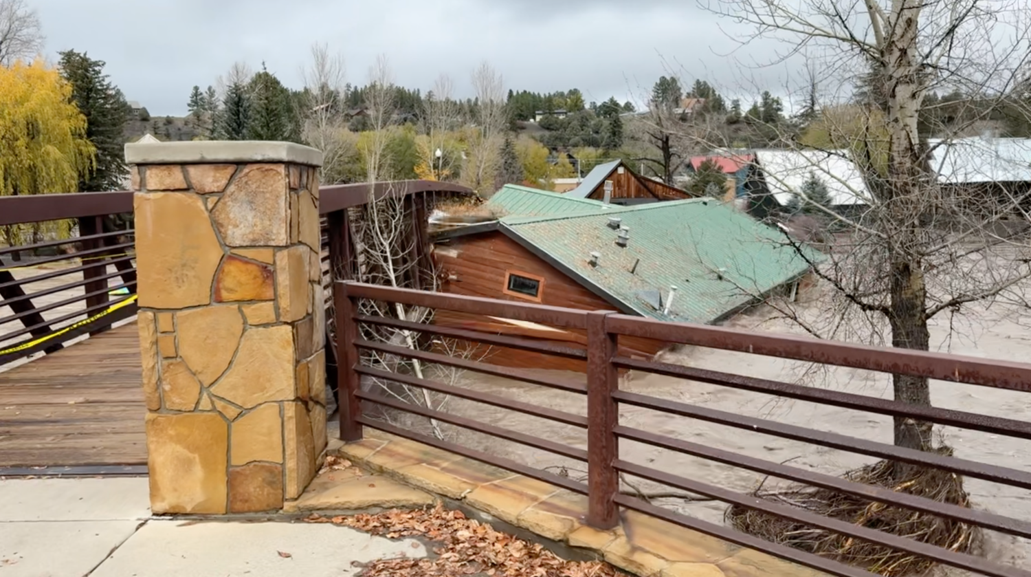
For the second time in as many weeks, Pagosa Country experienced historic flooding.
And, for the second week in a row, there have been no known fatalities or injuries associated with the flooding incident, according to incident officials.
How historic that flooding was in terms of the record books, however, remains to be seen.
The gauge on the San Juan River at Pagosa Springs registered 16.81 feet at about 8 p.m.
The latest river forecast ahead of the feet was nearly 22 feet.
Archuleta County Sheriff Mike Le Roux indicated during a community meeting on Tuesday, Nov. 3, that the San Juan River reached at least 2.5 feet higher on Nov. 1 and 2 than it did during the flooding that occurred on Oct. 23.
The San Juan River peaked at 15.02 feet at about 5:45 a.m. on Oct. 23.
“The last time the gauge read was at 16.9 feet,” Le Roux said. “We do have figures that were working on getting that accurately quantified, but we understand it to have been in the region of 17 plus feet, which, if it exceeded 17.8 feet, it would’ve exceeded the all-time measured record for anything in this region, ever.”
The 1911 flood peaked at 17.8 feet.
According to U.S. Geological Survey (USGS) Supervisory Hydrologic Technician Bryan Moore, the San Juan River reached a height of 16.81 feet at 8 p.m. on Nov. 1.
In an email to The SUN, he notes, “That is the current provisional value we are displaying at San Juan River at Pagosa Springs.”
Moore also notes that there was a loss of data recording around 10 p.m. on Nov. 1.
Moore writes, “The next morning, a technician found a collapsed bridge railing which the stage sensor wiring was attached to.”
He notes that the gauge was then reconnected, adding, “We’re hopeful we captured the peak value, but we have some more interpretation to do before we can be certain.”
Moore also notes that process may take awhile and that any “additional analysis could affect our final computed peak discharge value.”
Last year, Pagosa Springs experienced what were then the third and fourth largest flooding events in record history with the San Juan River, peaking at 12.82 feet and 12.66 feet.
River levels
The other rivers that run through Archuleta County also experienced record flows early this week, according to National Water Predictions Service and Colorado River Basin Forecast Center data.
The Piedra River near Arboles hit 10.66 feet late Nov. 1, surpassing its previous records of 6.4 feet and Oct. 23’s 10.48.
The Navajo River near Chromo hit 8.78 feet early Nov. 2, surpassing Oct. 23’s 7.8 feet and the previous record of 5.1 feet.
The Rio Blanco near Pagosa Springs hit 5.67 feet early Nov. 2, just topping last time’s 5.56 feet and the previous record of 5.26.
Rain totals
According to reports entered into the Community Collaborative rain, Hail and Snow Network (commonly called CoCoRaHS), between 2.7 and 4.57 inches of rain fell across all parts of Archuleta County from Oct. 29 through Nov. 2.
The highest report was 4.57 inches 7.2 miles northwest of Pagosa Springs.
Wolf Creek Ski Area reported a total of 12 inches of snow in the latest storm, bringing the yearly snow total to 39 inches so far.
Damage on damage
Like the previous flooding, this week’s again contributed extensive damage to roads, homes and other critical infrastructure all throughout the county.
Archuleta County Commissioner Warren Brown indicated at a community meeting on Oct. 27, that 800 structures in the county had been impacted by the first round of flooding in October, with 540 of those structures being homes.
On Nov. 3, Incident Commander Charles Balke explained that, after the waters started receding, they were able to start getting “some boots back on the ground” to do ground for assessments, and were able to do some air reconnaissance flights.
He noted they were able to identify some areas of concern along County Road 500 and have started building plans for those who had been cut off and not able to get out.
Archuleta County Sheriff Mike Le Roux noted mandatory evacuations were left in place in the week before the second flood due to ongoing risks and operations.
He noted that the second flood peaked nearly 2 feet higher, and some things that were hanging on and survived the first storm “didn’t do as well the second time around.”
Balke noted the damage from the second storm wasn’t anything that incident managers weren’t expecting given the predictions.
He noted there were areas that sustained a little more damage than predicted, but, overall, there was not damage they were not anticipating and trying to prepare for.
The flooding also caused a fiber line break due to surface runoff, which took out cellular and some internet capabilities. Services were restored the evening of Nov. 3.
Le Roux also noted the damage to roads, bridges and the power grid.
Balke noted two rescue missions have taken place during this fall’s flooding — the hoist mission during the first flood and a more recent rescue of a resident due to the inability to access them and the need to evacuate them and their livestock in a timely manner to avoid a “catastrophic event.”
During the reconnaissance mission, Balke indicated, they were able to view that property.
“Had we not been able to get that person out at that point in time and the livestock out, it could have been a much grimmer reporting on rescues,” Balke said.
Le Roux noted there have been other evacuations that have taken place, with Balke noting about 50 people have been evacuated, as well as a number of animals.
The pair also addressed the unverified, preliminary number of buildings and homes affected.
Balke noted that, as of the morning of Nov. 2, they were working on the number of homes affected.
Balke confirmed that a house was swept from San Juan Street in town and demolished by a bridge.
He explained that, in some of the remote areas of the county, “We did lose several more homes.”
He added some they knew would be losses due to the ongoing flow.
He guessed that perhaps 10 to 15 homes in the rural community in Archuleta County may have been lost.
Le Roux noted that, within the unincorporated area, there were 1,228 buildings in the affected areas and that they will work to identify what is not there.
Returning home
As of press time Wednesday, Nov. 4, all of the county’s evacuation orders remained in place. The town lifted a portion of its evacuation order on Tuesday, Nov. 2, for areas not impacted by flood water.
“As people start making their way in, they’re going to have to realize the system is still overloaded and taxes,” Balke said, adding that no timeline for nonemergency help can be guaranteed.
He also suggested people should be prepared for what they will see when they re-enter following evacuations.
“Some of the properties have very significant damage to it, where other properties have very minor damage,” he said. “So, we just want people to be mentally prepared that they could be returning to areas that have experienced significant damaged.”
He acknowledged the significance of things to people.


 >