The San Juan National Forest is planning prescribed fire operations as early as March 23, pending all required approvals.
We estimate this work to continue through the spring months as weather conditions allow.
We use prescribed fires on all three districts of the San Juan National Forest to help reduce overgrown vegetation, protect local communities, infrastructure and natural resources from wildfires, and to restore ponderosa pine ecosystems.
Find additional details on InciWeb. Prescribed fires planned for the San Juan National Forest include the following.
Pagosa Ranger District
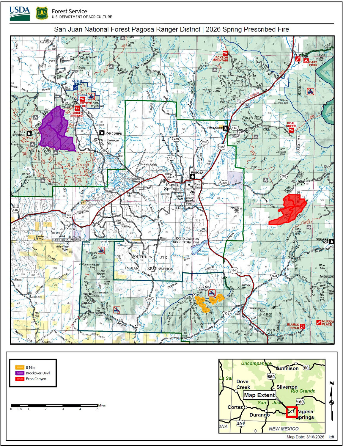
Beginning in late March, the Pagosa Ranger District plans to implement multiple prescribed fire projects in Archuleta County as weather and conditions allow.
• Echo Canyon Prescribed Fire: This 1,139-acre project is located along NFSR 029 southeast of Pagosa Springs and east of U.S. 84. In 2018, this project area was the site of commercial thinning, followed by mastication work in 2021 and prescribed fire in 2023. This year, the district hopes to conduct a “maintenance” burn to maximize fuel reduction benefits.
• Eight Mile Mesa Prescribed Fire: This project is located on Eight Mile Mesa (NFSR 651), south of Pagosa Springs and west of U.S. 84. A total of 275 acres will be burned to clean up slash and forest litter following a 2022 oak mastication project as well as other hazardous fuels and timber harvest activities.
• Brockover-Devil Prescribed Fire: This 2,100-acre project area consists of “maintenance” burning, further reducing ground and ladder fuels. This treatment will build on the 2025 fall prescribed fire operations in the area and complement numerous mastication, thinning and timber harvest treatments. These units are located along NFSR 629 and 923, west of Pagosa Springs and north of U.S. 160.
Columbine Ranger
District
Beginning as early as March 23, the Columbine Ranger District will begin the following prescribed fire projects as conditions allow. Smoke will be visible from Arboles, Bayfield, Pagosa Springs, as well as the U.S. U.S. 160 and Colo. 151 corridors near those towns.
• Northern HDs Prescribed Fire (Sauls Creek): This project will include multiple units totaling approximately 900 acres. This project is located in Sauls Creek near NFSR 608, east of Bayfield and south of U.S. 160 in La Plata County. This project is part of a larger fuels reduction strategy that has included commercial logging and other fuels reduction work.
• Southern HDs Prescribed Fire: This project is approximately 2,000 acres in the Fosset Gulch area (NFSR 613), west of Chimney Rock National Monument in Archuleta County. Units will be burned using ground ignitions and possibly unmanned aircraft systems (drones) as well. In past years, the Columbine District burned adjacent units to help reduce wildfire risk to local homes and infrastructure.
Dolores Ranger District
The Dolores Ranger District plans to begin prescribed fire implementation in early April. During burning operations, smoke may be visible around Mancos, Dolores, Dove Creek, Cortez, and U.S. 491 between Dove Creek and Pleasant View. Smoke may settle into low-lying valleys and the Dolores River Canyon overnight.
• Boggy Draw Prescribed Fire: This 4,107-acre project is located 4 to 8 miles northeast of Dolores in Montezuma County, along NFSR 526 and 527. Smaller units of this overall project will be implemented as weather and conditions allow.
• Salter-Carlyle Prescribed Fire: This 1,660-acre project is located 15 miles east of Cahone, near Salter Y along NFSR 510 in Montezuma and Dolores counties.
More information
Residents may experience smoke during the prescribed burns. Prescribed fire smoke may affect your health. For more information, visit cdphe.colorado.gov/apcd/wood-smoke-and-your-health.
For more detailed information about air quality, go to AirNow online or download the app.
Watch for warning signs along roads near all prescribed fire areas before and during burns. When driving, slow down and turn on your headlights when you encounter smoke on the road.
Weather to be evaluated prior to burns
We will evaluate weather conditions in the hours before a burn begins. If conditions warrant, scheduled prescribed fire activities may be canceled.
Stay informed about the scheduled prescribed fires through the forest website, social media channels and InciWeb, the interagency incident information system.
We will notify county emergency management officials when burning begins.


 >
>