July 3, 2023 9:00 am
Rocky Mountain Area Complex Incident Management Team Three
Matt Spring, Incident Commander
Date Reported: June 28, 2023
Cause: Lightning
Size: 459
Containment: 0%
Total Personnel: 463
Location: 12 Mile west-northwest of Pagosa Springs, CO
Special Note: A Fire Weather Watch is in effect today for hot, dry conditions and gusty winds. Tomorrow, July 4, there is a RED FLAG WARNING in effect.
Current Situation: Fire behavior was moderate yesterday due to partly cloudy skies and spotty precipitation from passing thunderstorms. The fire continued to back down the West Fork Devil and the main Devil Creek drainages. Storm cells passed over the fire area, but little precipitation was recorded. Fire behavior should be similar today; winds from the west-southwest may become gusty and erratic with thunderstorm development, and if winds and topography align, fire behavior could increase.
Yesterday, aerial resources were able to assist in moderating fire behavior along the northern and eastern edges, slowing the fire’s progress as it backed into Devil Creek drainage. Aircraft achieved a total of 13.5 hours of flight time before thunderstorm outflow winds created unsafe flying conditions. Crews have completed direct fire line along the western edge from Snow Angel Ranch north to the “bowl” at the north edge of the fire. Today, they will secure and hold this line. On the south side, firefighters are working east from Snow Angel Ranch to connect hand line with established dozer line and FS road 681. Roads in the area are prepared to be used as containment line if the fire does cross Devil Creek drainage. Road preparation includes removal of fuels on the fire side of the road, lessening the chance of fire crossing over. Last night, hotshot crews safely camped close to the fire area to increase work efficiency, a tactic that is referred to as “spiking out.” Structure protection measures at Snow Angel Ranch remain in place.
Weather & Smoke Information: A Red Flag Warning has been issued for Tuesday through the rest of the week due to expected high wind and low humidity. Throughout today, hotter and drier conditions are expected, with highs 81-85 degrees and relative humidity 10-14% Thunderstorm development in the afternoon could produce gusty and erratic wind.
Closures: San Juan National Forest has a closure order in effect: https://inciweb.nwcg.gov/incident-publication/cosjf-chris-mountain-fire/chris-mountain-fire-closure
Evacuations: Archuleta County has issued mandatory evacuations for Forest Road 628, effective June 28th, 2023. To sign up for emergency notifications, visit the Archuleta County Emergency Operations website. You may also find evacuation information on their Facebook page or call the Chris Mountain Evacuees Call Center: at 970-264-8373
Temporary Flight Restrictions: A TFR is in place at this time. TFR link: tfr.faa.gov/save_pages/detail_3_9743.html
Fire Information Phone Line: (970) 549-8799 Hours: 8:00 am - 8:00 pm
Facebook: www.facebook.com/profile.php?id=100094353994683 Email: 2023.chrismountain@firenet.gov
InciWeb: inciweb.nwcg.gov/incident-information/cosjf-chris-mountain-fire
PREVIOUS UPDATES:
Chris Mountain Fire Update
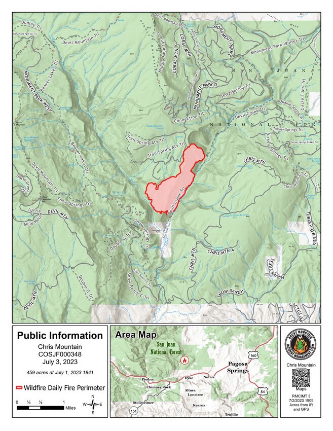
July 2, 2023 10:00 am
Matt Spring, Incident Commander
Date Reported: June 28, 2023
Cause: Lightning
Size: 459
Containment: 0%
Total Personnel: 365
Location: 12 Mile west-northwest of Pagosa Springs, CO
Current Situation: Fire behavior was moderate yesterday, with most of the growth on the north-northeast side and some growth in the southwestern corner. Fire is spreading mostly in timber understory, consuming ground fuels, and there has been some isolated tree torching. Fire behavior should be similar today; winds will shift again this afternoon to come from the west-southwest and may become gusty and erratic. This could increase activity and growth in the north and east sections as fire becomes established in the bowl just west of Devil Creek and as it backs down toward the Devil Creek drainage on the east.
Crews have successfully built fire line along the entire western edge of the fire, connecting into the west fork of Devil Creek, and extending south to Snow Angel Ranch. Yesterday, aerial resources supported firefighters’ work from above by dropping both retardant and water, flying for a total of 21 flight hours throughout the day. Today, crews on the west side will improve fire line and work to extend it around the southmost edge of the fire, north of Snow Angel Ranch. On the east side of the fire yesterday, helicopters dropped numerous buckets of water to slow the fire’s progress as it backed towards Devil Creek drainage and will do so again today. Firefighters are scouting for indirect line options east and northeast of the fire in the event it crosses to the east side of Devil Creek drainage. Near the south-east edge, hand crews and dozers are working off existing road systems to build indirect fire line from the roads to Snow Angel Ranch. Structure protection crews remain present near the Snow Angel Ranch and are also scouting and assessing near the Turkey Springs area to the northeast. Firefighters remain stationed overnight near Snow Angel Ranch and the Devil Creek Drainage to monitor for change in fire behavior.
Weather & Smoke Information: Hot, dry weather is predicted for the next several days as a high-pressure system builds across the west, with temps in the low to mid 80s. Relative humidity of 10-20% - slightly drier than recent days - will be common for the next few days. Today, humidity may be as low as 11-15% with a 20% chance of afternoon thunderstorms. There is potential for breezy conditions to return from Tues. through Thurs. (July 4 - 6), with gusts to 23 mph. These warm, dry, and breezy conditions will continue to dry fuels and make them more susceptible to ignition, potentially increasing fire activity.
Closures: San Juan National Forest has a closure order in effect: https://inciweb.nwcg.gov/incident-publication/cosjf-chris-mountain-fire/chris-mountain-fire-closure
Evacuations: Archuleta County has issued mandatory evacuations for Forest Road 628, effective June 28th, 2023. To sign up for emergency notifications, visit the Archuleta County Emergency Operations website. You may also find evacuation information on their Facebook page or call the Chris Mountain Evacuees Call Center: at 970-264-8373
Temporary Flight Restrictions: A TFR is in place at this time. TFR link: tfr.faa.gov/save_pages/detail_3_9743.html
Fire Information Phoneline: (970) 549-8799 Hours: 8:00 am - 8:00 pm
Facebook: www.facebook.com/profile.php?id=100094353994683 Email: 2023.chrismountain@firenet.gov
InciWeb: inciweb.nwcg.gov/incident-information/cosjf-chris-mountain-fire
Rocky Mountain Area Complex Incident Management Team Three
Matt Spring, Incident Commander
Date Reported: June 28, 2023
Cause: Lightning
Size: 348
Containment: 0%
Total Personnel: 302
Location: 12 miles west-northwest of Pagosa Springs
Current Situation: Management of the Chris Mountain Fire transitioned to the Rocky Mountain Area Complex Incident Management Team Three Friday evening at 8:00 pm. The fire is on the San Juan National Forest, Pagosa Springs Ranger District and was reported on June 28th. Over the past few days, the fire has slowly backed into the Devil Creek Drainage. The fire is removing understory debris with occasional single tree torching.
Crews will engage the fire directly where the vegetation and terrain allow them to do so safely. Additional crews, engines and overhead resources arrived on the fire yesterday. Crews were able to build approximately one mile of direct handline utilizing a network of trails and roads on the northwest portion of the fire. Today, crews will continue constructing line on the western side moving south. On the southern end of the fire, crews will begin constructing line north of the Snow Angel Ranch creating an anchor point. On the east side of the fire, crews and overhead will scout locations for primary and secondary containment lines. Fixed and rotor wing aviation will be utilized to slow the fire progression and assist the crews on the ground.
Residents and travelers should expect to see an increase in fire vehicle traffic in Pagosa Springs.
Weather & Smoke Information: The weather will continue to be warm and dry. Temperatures today will reach in the mid-80s over the fire area. The relative humidity is expected to be around 18 percent. There is a small chance for afternoon thunderstorms, but no measurable precipitation is anticipated.
Closures: San Juan National Forest has a closure order in effect: https://inciweb.nwcg.gov/incident-publication/cosjf-chris-mountain-fire/chris-mountain-fire-closure
Evacuations: Archuleta County has issued mandatory evacuations for Forest Road 628, effective June 28th, 2023. No structures have been lost, but some near the heel/southern end of the fire are considered threatened, prompting evacuations. To sign up for emergency notifications, visit the Archuleta County Emergency Operations website. For current evacuation information, visit their Facebook page or call the Chris Mountain Evacuees Call Center: at 970-264-8373
Temporary Flight Restrictions: A TFR is in place at this time. TFR link: tfr.faa.gov/save_pages/detail_3_9743.html
FIRE NAME INFORMATION
Fire Information Phoneline: (970) 549-8799 Time: 8:00 am - 7:00 pm
Facebook: www.facebook.com/profile.php?id=100094353994683
Email: 2023.chrismountain@firenet.gov
InciWeb: inciweb.nwcg.gov/incident-information/cosjf-chris-mountain-fire


