The Chris Mountain Fire on the San Juan National Forest Pagosa Ranger District was reported on June 28th, 2023 at 3:00pm. The 200-acre fire is burning on Chris Mountain, located approximately 12 miles west of Pagosa Springs, north of Highway 160. The fire is burning in Ponderosa Pine and timber on National Forest System Lands and has not crossed onto private property at this time. Archuleta County has issued mandatory evacuations for Forest Road 628, effective June 28th, 2023. No structures have been lost, but some near the heel of the fire were considered threatened, prompting evacuations. To sign up for emergency notifications, visit the Archuleta County Emergency Operations website(link is external) (http://archuletacounty.org/569/Citizens-Alert---NIXLE) and to get current evacuation information visit their Facebook page(link is external) (https://www.facebook.com/search/top/q=archuleta%20county%2C%20co%20sheriff%27s%20office) or call the Chris Mountain Evacuees Call Center: at 970-264-8373 (tel:970-264-8373).
OPERATIONAL PERIOD OF JUNE 30TH, 2023
Evening update:
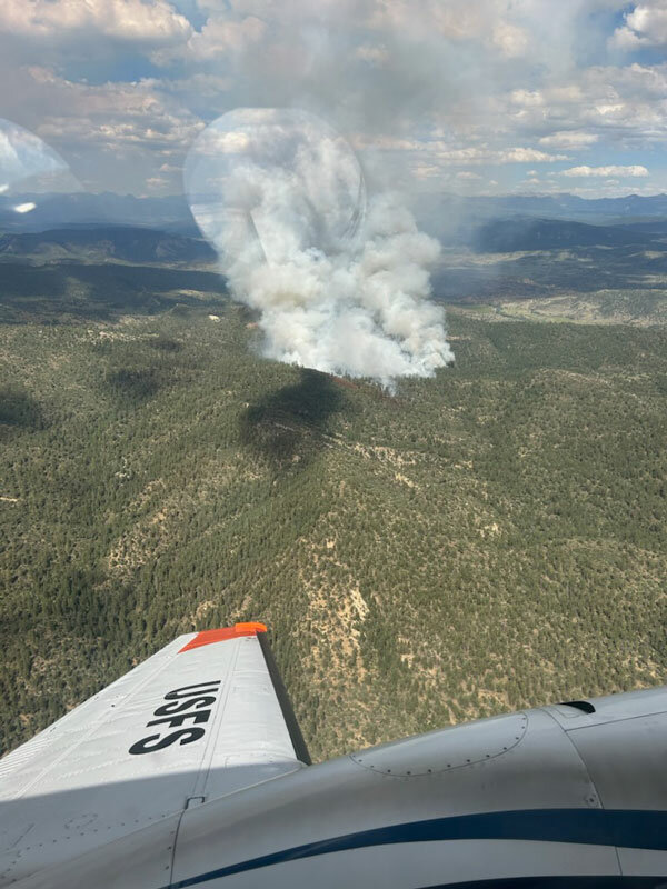
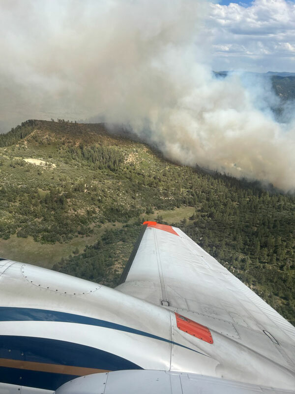
Fire behavior has picked up some this afternoon and was mapped by infrared at 347 acres. The fire has been backing down the Devil Creek drainage and moving slowly north. Single Engine Air Tankers (SEATs), Large Air Tankers (LATs), and multiple helicopters are helping to slow the fire's spread at the heel of the fire near private property.
Yesterday, the fire began to cross through retardant lines that were established on June 28th and reinforced June 29th. Retardant is only effective when wet and when firefighters on the ground can reinforce it with hand line. Due to difficult terrain and heavy fuel loading in the Devil Creek drainage, firefighters are unable to engage the fire on the ground. In anticipation of the fire potentially crossing the creek drainage, crews are prepping contingency line and roads. On the northeast side, three interagency hotshot crews are engaging the fire directly, digging fire containment line. Crews are also working to protect the Tri-State power line. Many resources arrived today, including bulldozers, fire engines, hand crews, and more. Fire managers anticipate making progress on the fire over the weekend.
The Rocky Mountain Complex Incident Management Team 3 will take command of the fire at 8pm. The team will provide additional capacit
y for all functions of fire management, including public information. Be prepared to see a significant rise in local traffic from firefighters and their support team.
The San Juan National Forest Type 3 Incident Management Team posted the following update midday on Friday, June 30:
The Chris Mountain Fire on the San Juan National Forest Pagosa Ranger District was reported on June 28th, 2023 at 3:00pm. The 200-acre fire is burning on Chris Mountain, located approximately 12 miles west of Pagosa Springs, north of Highway 160. The fire is burning in Ponderosa Pine and timber on National Forest System Lands and has not crossed onto private property at this time. Archuleta County has issued mandatory evacuations for Forest Road 628, effective June 28th, 2023. No structures have been lost, but some near the heel of the fire were considered threatened, prompting evacuations. To sign up for emergency notifications, visit the Archuleta County Emergency Operations website and to get current evacuation information visit their Facebook page or call the Chris Mountain Evacuees Call Center: at 970-264-8373.
OPERATIONAL PERIOD OF JUNE 30TH, 2023:
The fire grew slightly yesterday, but the increase in acreage from 120 acres to 200 was mostly due to more accurate mapping. An aerial mapping operation has been requested and will provide updated acreage later today.
Yesterday, the fire began to cross through retardant lines that were established on June 28th and reinforced June 29th. Retardant is only effective when wet and when firefighters on the ground can reinforce it with hand line. Due to difficult terrain and heavy fuel loading in the Devil Creek drainage, firefighters are unable to engage the fire on the ground, so retardant operations have ceased temporarily. Helicopters will continue to drop water on the heel (southernmost end of the fire) today where they can be effective in protecting the private properties. Fire activity is moderately active as of 9am, and fire managers are beginning to scout ahead of the fire (to the north and northeast) for containment options.
Resources are arriving to the Pagosa Springs area from around the country to help fight the Chris Mountain Fire. Rocky Mountain Team 3 Complex Incident Management Team (CIMT) will be taking command of the fire at 6pm tonight. The team will provide additional capacity for all functions of fire management, including public information. Be prepared to see a significant rise in local traffic from firefighters and their support team.
Early Friday morning, the San Juan National Forest Type 3 Incident Management Team updated the acreage of the Chris Mountain Fire to 200 acres with 0 percent containment and provided the following update about June 29:
Towards late afternoon, the cloud cover that had been prevalent most of the day cleared out. With the hotter temperatures, sections of the east flank in Devil Creek drainage began to cross over retardant lines. Single and group tree torching occurred in pockets along the east flank. A medium and light helicopter both worked to cool down the hot spots along the line, but fire managers are considering tactical alternatives if they cannot prevent the fire from reaching the drainage bottom. The fire grew slightly, but the increase in acreage today from 120 acres to 200 was mostly due to more accurate mapping.
San Juan National Forest Type 3 Incident Management Team
Mandatory evacuation issued for Forest Road 628
The San Juan National Forest Type 3 Incident Management Team reported the following about the Chris Mountain Fire:
Midday Update, June 29, 2023:
Fire managers have confirmed that fire has been kept out of the Devil Creek drainage and the fire held within yesterday’s retardant lines. A Type 1 Helicopter and a Large Airtanker are focused on dropping water and retardant on the east flank of the fire, continuing to prioritize keeping fire out of the drainage. There is strong competition locally and throughout the country for aviation resources as emerging wildfires are on the rise.
The San Juan National Forest Type 3 Incident Management Team reported the following shortly before 10 a.m. Thursday, June 29:
The Chris Mountain Fire on the San Juan National Forest Pagosa Ranger District was reported on June 28th, 2023 at 3:00pm. The 120-acre fire is burning on Chris Mountain, located approximately 12 miles west of Pagosa Springs, north of Highway 160. Archuleta County has issued mandatory evacuations for Forest Road 628, effective June 28th, 2023. To sign up for emergency notifications, visit the Archuleta County Emergency Operations website and to get current evacuation information visit their Facebook page.
OPERATIONAL PERIOD OF JUNE 29TH, 2023: The Chris Mountain Fire is burning in Ponderosa Pine and timber. Fire behavior decreased during the evening of June 28th. No structures have been lost, but some near the heel of the fire were considered threatened, prompting evacuations. Overnight, a “structure group,” or a firefighting team assigned to protect structures, established hose lays around threatened properties to further protect them in case fire approaches. The fire remains on National Forest System Lands and has not crossed onto private property at this time. Firefighters will begin scouting the fire on the ground and are formulating a plan for how to safely and effectively contain the fire. Firefighter and public safety are the top priority, followed by structure protection. Aircraft will be seen throughout the day, potentially dropping water and retardant, as well as circling the fire to gather information, provide aerial supervision, and to map the incident.
The local San Juan National Forest Type 3 Incident Management Team took command of the fire in the morning on June 29th. They will be implementing an area closure for public and firefighter safety. We ask that the public stay clear of the fire area. We are working hard to produce a map for the public. This is an emerging incident with many priorities, so we appreciate your patience as we pull together materials.